Comanche Peak B-24 Trips
This is what wreckchasing can be like.
In Search of: A B-24 Near Crown Point Perhaps?
9/1994 - 8/1995
The Clues:
(1) Brief conversation with hikers met on the Brown's LakeTrail (Comanche Peak Wilderness Area; Colo.) that there was an old bomber 'up there' that was mostly intact. Looked like it smashed into a rockpile. I can't recall their directions (if any). This was about 1985. They came from the southeast off the ridge just north of Brown's Lake.
(2) Civil Air Patrol lists '4 engine unknown, intact' in vicinity. Comments show two choices: 4 NW Comanche Pk. OR Between "Brown's Reservoir" and Crown Point. Note that the map shows a Brown's LAKE and a COMANCHE Reservoir.
(3) Next door neighbor, Harvey, said he saw the wreckage a long time ago (late 40's?) when on a trip to Brown's Lake. Shining wreckage waaay up on the ridge S of Brown's Lake . Waay up there. As high up as you could see. His uncle hiked up to it. Said it was mostly intact except for the front where it had run into a rockpile. 'woulda been ok if they'd been 15 feet higher' Were on the way to Denver in cloud. Not sure of year seen or crashed. Wreck reported to have been sanitized by the Army of: machine guns, bombsight,radios. Harv's uncle said other stuff gone too. Thinks it was a B-24.
(3.5) Reports from researchers of a letter written by a Larimer Deputy in 1972 describing his experiences of the time. Was first to the Crown Pt B-17 crash. Said he also helped with another wreck "half mile from" the Crown Point site. Description of corpses in 2nd crash however, matched that of the Stormy Peaks B-17.
Hikes taken to prove the CAP coords (or not):
DAYHIKE - 9/4/94 Search Crown Point area ridge just north and west of Brown's Lake for "intact" 4 engine bomber that Harvey said he could see from Brown's Lake in early 50's. W.Joe Battin. No luck.
DAYHIKE- 9/8/94 Crown Point again. Up W. Fork Sheep creek to ridge around west of Brown's Lake. No joy.
DAYHIKE- 9/9/94 Crown Point again. Up E. Fork Sheep creek. Circled Brown's Lake to dead south of the lake at 10,960'. No joy.
DAYHIKE- 9/17/94 Crown Pt again. Thoroughly worked over the knoll directly west of Brown's Lake. Anyplace that the lake could be seen from. No joy. 6 hrs. => Seems that N or W of Brown's Lake is empty. First knoll SW of Brown's has no view of the lake even though it could be a likely crash site to Southbound A/C. "4 NW of Comanche" is the knoll or further North. Lesser distance puts it onto Comanche ridge.
NOTE- Even CAP acknowleges that locations can be off by several miles.
Locators may not know local terrain very well or use sufficient care in plotting on appropriate scale maps. It's possible that USAF coords have been corrupted down thru the years and CAP has never re-verified.
Other Methods:
1. Aerial photos- Duke Sumonia, a historian and retired cartographer living in Estes Park obtained some photos of the area. Brought them by my house and we looked pretty intently. Scale of pictures isn't appropriate. Identified a shadow on the tundra but it's doubtful. Marked on map for ground investigation later. Entered coords into GPS. =>subsequently proven to be plants. No airplane.
2. Oral history- Talked to Roosevelt NFS- Ginny Deal, John Slay, Ellsperman. No joy.
- RMNP. Talked to Jim Protto, Ron Thomas about Comanche Pk. north boundary expansion in 1980. No joy.
Ron Thomas willing to allow Duke S. to view survey photos at 1:15700 scale of N. Boundary. Done. No joy.
3. Aerial photos- Ordered 36" x 36" blowup of Comanche area via USGS. Should arrive 4-6 weeks (from 3/27) Source is same photo flight that Sumonia has pictures from. Hopefully the blowup will reveal new details.
- Got the picture. It covers about 9 sq miles. Close scrutiny indicates that Duke's picture with the suspicious shape is probably willows. Several other interesting shapes are visible but none are conclusively an aircraft. => shapes entered in GPS and visited. No joy.
4. Oral history- requested HP folks on Alan Silverstein's 'hikers' mailing list for info. (3/20/95) Got back polite interest but no new info. This request is easily confused with the Crown Point B-17 publicity of summer '94.
5. FLYBY idea- Jer Eberhard (CAP) interested and willing to do air search. Mountain qualified search pilot, should work pretty well when tried. Requires snowpack to melt to be effective. Might be workable earlier in the year than foot search since trailhead access and under-tree movement could still be snowbound when tundra becomes largely snow-free. Tundra will be north-facing slopes though.
6. BACKPACK ATTACK Idea- Backpack to vicinity of Monroe Cabin in afternoon. Up early to get headstart on trail & searching flanks of Comanche. Spend all day searching if needed. Overnite at cabin again. then out. Or search on 2nd day, then out? (This is the trip report below.)
1995 trips
DAYHIKE on 7/3/95- Drove jeep thru snowdrifts on the Crown Point Road to get to Brown's Lake Trail. Hiked to Crown Point thru thigh-deep snowdrifts under the trees to summit. Hid out of wind and used binocs to scan Comanche Ridge. After long time of looking, determined that so much snow remains up there that even if 8x magnification could normally detect, not this time. Wait for more melt.
Idea- get spotting scope from Sportsman's Club locker. Spend lots of time carefully scanning the ridge for likely spots. If it could be seen from Brown's Lake, it should probably be visible from Crown Pt.
DAYHIKE on 7/15 with spotting scope to scan Comanche Ridge from Crown Pt. Got 45x scope from Club. Glassed ridge for >1hr. No joy. Not sure if remaining snow obscures or terrain obscures , or the wreck is collapsed or not there. Went to the Crown Pt. B-17 site again to refresh motivation. First hike with young friend Thomas Gallegos.
BACKPACK ATTACK- Executed the plan from 8/1 to 8/4. Camped in Willow Creek drainage. Hiked all over north side Comanche Peak looking with naked eye, binocs and plotted progress with GPS. Noted that even from the summit or the false summits of Comanche, Brown's Lake water is not visible. However, the slope down to the water's edge is visible in portions from many places depending on how high up the slope from the water is reference.
No find on Comanche. No find on the smaller ridge to the north of Comanche. Then did dayhike from camp to Comanche Lake. (tough territory to bushwhack thru) Contacting Jer/ for flyby arrangements as of 8/7. Plan to do early AM of 8/15
DAYHIKE on 8/13 to try "half mile from wreck" theory. Walked the woods & bushes to 0.3 mi from the Crown Pt. site.No joy.
FLYBY on 8/15/95- 2.5 hrs in C182 searching Comanche, Crown Pt area. No joy.
Interim Conclusions-
(1) Unlikely that there is an intact airplaneon the tundra in the areas searched.
(2) Descriptions seem to make airplane in the trees unlikely
(3) Even with knowing where to look, seeing the Crown Pt. B-17 proved surprisingly difficult.
(4) Need to re-evaluate clues.
CONCLUSIONS and analysis-
Clue #1 Hikers- Hikers were coming in the right direction to have been to the Crown Pt. B-17. Range and direction is right for dayhike. Discontinuity in the story is their definition of "intact"
Clue #2 CAP- Data is notoriously unreliable, especially bad for WWII era wrecks. It is possible that this is the Crown Pt B-17 location. Might require that Comanche Reservoir or Hourglass Reservoir be misidentified as Brown's. If Comanche Res. were substituted, then description would fit Crown Point B-17 after downing but before dynamiting.
Upon even more careful reconsideration - 2 more points.,
1.I note that the CAP list has NO entry for the Crown Point B-17. The Stormy Peaks B-17 coords were 5 miles off. The '4 eng unknown' is inside 1 mile from the Crown Point B-17 actual site. The other 2 B-17 wrecks in Larimer County are listed as B-17 wrecks.
2. The site description for a 1950 airliner crash is as if it had happened yesterday. The site did not look that way for very long. Could the text entered on the CAP's list be the INITIAL DESCRIPTION?
Clue #3 Harvey- Physical position of Twin Lakes Res. matches his description of shining, directly south and up high. The Stormy Peaks B-17 wreck would have been in recognizable pieces at the time of his sighting and would be dead south of Twin Lakes. Renamed the lake? Harv misidentified the lake? His story of jeeping in to Brown's lake seems somewhat unlikely since Browns is a much more difficult drive than Twin Lakes.
Note- does not match '15 feet higher and they would have been ok'
Clue #3.5- This seemed unreliable from the first. The wreck descriptions match the B-17 sites. Only the distance is off. Could it have been written as "5 miles" and read as ".5 miles" ??
I have reached the 90% confidence point where I believe that there never was another wreck. I was chasing a hodge-podge of distorted clues.
Backpack Attack to search for the B-24.
This trip started out as a backpack trip thru RMNP but we (my regular backpacking buddy Jeff Bossenbroek and I) were blockaded by a snow cornice on the route we’d intended to take. There was no alternate route so the RMNP trip was scrubbed. This trip report was posted to the internet newsgroup rec.backcountry afterwards.
Trip Report- July 1995. COMANCHE PEAK WILDERNESS AREA
==========================================================================
7/31 - Monday. After failing to clear an obstacle in the way of a long-planned backpack trip in RMNP, Jeff and I bailed out of the trip. We’d had a very hard day of backpacking up from our camp to a snowfield guarding access to McHenry peak and we had decided that the snowfield was corniced and too steep for our skills under those conditions. So, Jeff redeemed his Mileage Plus coupons and went to San Diego to join his wife with her sister.
I creaked around the house reorganizing and repacking for a solo trip back out. I exchanged the 2 man tent for a 1 man, recovered the stove and fuel bottle from Jeff and then downsized the spare fuel. I dumped the ice axe, added my pistol in its field holster and was ready to go out again Tuesday after a clothes wash, a shower and a good night's sleep . The swelling on my hip bones from Sunday's abuse (our packs were awfully heavy and we carried them for about 14 hrs) receded with 24hrs off.
8/1 - Tues. COMANCHE PEAK WILDERNESS AREA (Roosevelt NF)
EXPLANATION- For most of the last year I have been working on relocating old airplane wrecks. I have located 2 B-17 bombers, a C-46 cargo plane and a DC-6 airliner( United; 1950). Relocation is done with a GPS to get sure position to correct the Civil Air Patrol data that is 6 to 24 miles off. I have been on the trail of a possible B-24 crash in the Comanche Peak Wilderness area for at least 6 daytrips. This particular wreck is tantalizing because it is reported to be mostly intact instead of removed like the C-46, totally burned like a B-17 , demolished with dynamite like another B-17 or buried like the Crystal Mountain DC-6. The plan for this solo backpack trip was to establish a base camp in a place that would allow me to hike and search the Comanche Peak ridge thoroughly.
0800 Rolling out of Ft. Collins. Clear day, little traffic on a weekday.
1015 Zimmerman Trail Trailhead at the end of the Crown Point Rd.. Nice clear day. 1 other vehicle at the TH - a horse trailer and pickup blocking all the car spaces at once. I parked under a pine tree in the horse trailer pullthru. I head out at a very, very slow pace. As I proceed, I take waypoints with the GPS at trail junctions (Flowers Trail) and places of interest along the way. It will be an experiment to see how the waypoints check in reverse on the way out several days from now.
1320 After transiting the Zimmerman trail and taking the western tending Flowers Trail then branching off from Flowers to the Mirror Lake trail, I reach the shoulder of the mountain overlooking the Willow Creek drainage. A word about 'trails' here. Some are actual paths in the tundra but as one gets further from trailhead, the grass damage wanes and 'trail' becomes marked by rock cairns only. This area is at and above treeline so the views are spectacular and the navigation quite simple unless you get confused as to which saddle or ridge you are on. Near the top of this drainage is an intersection with the Mirror Lake trail and a more direct route up and over the rounded ridge back toward the Flowers Trail and the Zimmerman Trail. I sit down and enjoy the clear weather and the view of the Comanche ridge. I eagerly scan with binoculars for the airplane wreck up on Comanche. No joy. After awhile, I move along and, with a fair amount of searching, find a suitable campsite on the north side of a tributary to Willow Creek. Level spots are remarkably scarce here. I have camp setup by 1500 at an altitude of around 11,000'. (I record the camp coords in the GPS for current use and for later return if desired.)
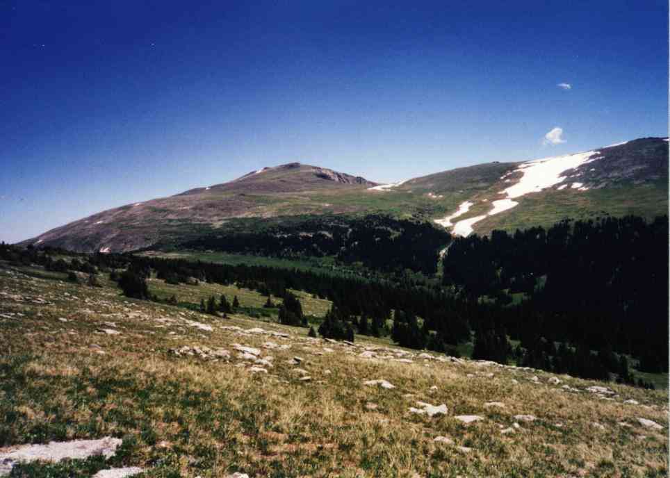
(Click on pictures to get enlarged image)
|
| Comanche Peak overlooking Willow Creek drainage. |
2000- After a dehydrated lasagna dinner for 1 and a quiet evening, I hit the sack. The mosquitoes make staying out very long quite annoying. And, since there is no one to talk to, and no place to go, bed & a little reading are the thing to do. I leave the rainfly off the tent but about 2100 find that with the downslope evening air movement it is too cold for that and replace the fly, put on my stocking cap and neck gaitor and zip in for the night. There was ice in one water bottle outside the tent in the morning.
8/2 Wed - 0700 up and getting breakfast. The day is totally clear but windy.
0800 Underway up the hill slowly. I rest step occasionally and scan the ridge with binoculars to cover the territory thoroughly. As I go, I mark waypoints in the GPS about every 20 minutes or so for plotting later. The unit works great up here in the clear. The nature of the shelves on the ridge mean that I could miss some areas. Still, I get a look into the Mirror Lake basin inside RMNP and marvel at the effort it would take to go to Mirror Lake by way of the trails I've used (long, exposed, must transit high elevations and make a big descent )
1200 I reach the summit of Comanche Peak (12,7xx'). I found no airplane along the way but have meandered just below many of the ridgetop rockpiles (info says the plane "would have been ok if he'd been 50' higher"). It's really, really windy on top but that seems to keep any cumulous clouds from developing. The view is fine and I note that I cannot see the shore of Brown's Lake which was reported to be one point at which one observer could see sunlight reflecting off of the wreckage when it was fresh.
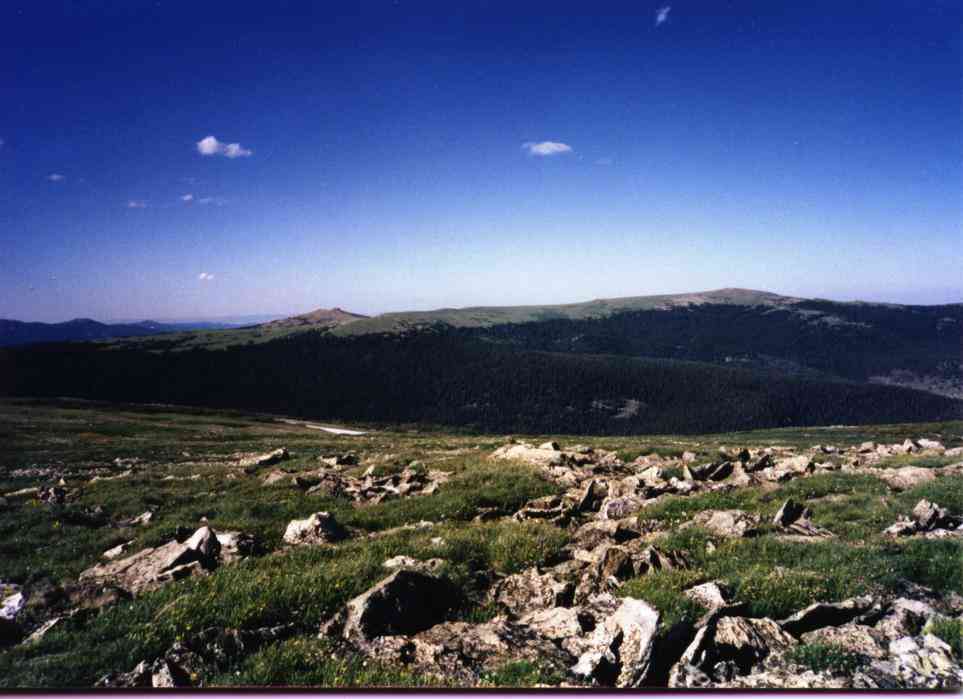 |
 |
 |
| Crown Point where Crown B-17 lies from afar. | Long Draw Reservoir from Comanche summit | Mirror Lake in RMNP from Comanche |
1400 I am off Comanche after transiting right across waypoints I'd programmed into the GPS that corresponded to suspicious shapes on the ground shown in aerial photography. I take pictures of the 'shapes' made of different colored grasses/plants. No airplane wreck. Since I was on the opposite side of Willow Creek from camp and still had altitude and daylight left, I decided to head for Munro cabin, a mysterious point on some maps.
I sidehill along on the tundra to the end of a rounded point just above treeline. No cabin. I poke around in the trees just downhill. No cabin but some tree stumps. Stumps from the logs used? I get discouraged and start to take a direct beeline angling down the hill to the creek crossing. As I proceed I trip across-
1530 Munro cabin. The cabin is remarkably intact. Log sides, small framed paneless windows, a huge diameter ridgepole log and a healthy turf roof. Inside are shelves, an oil-drum stove and lots of old dust (and perhaps Hantavirus?). The door works and the shack seems pretty secure. Why is this here? It's a LONG way from anywhere and there was little or no mining in the area. Hmmm? I suppose that this might be a better deal for Fall hunters than tents. But I am wary of the dust inside. I'd sure wait out a rainstorm here though if it were convenient.
I take some pictures for the record and depart for camp.
 |
| Munro Cabin |
1630 Back at camp footsore and disappointed, I relax and think about the long day I'd just had. What next? I don't think I can face climbing Comanche again tommorrow. I'm 80% confident that I've done a good job searching it. Where is that durned airplane?
1730 Dinner is Alpine Aire Apple Almond Crisp (very bland) and some other nibbles. Pretty dull. (yes, it's a desert. But I'm trying to eat down the heaviest items first and I'd been lugging this around on trips during the last 2 years....)
1900 In bed and reading.
8/3 Thurs- 0730 up and find the air is still but there are some high pastel clouds to the west. (moisture) I slowly hike to the top of the hill along the more direct trail. This goes to the summit of a small rounded ridge just northwest of Comanche ridge and between Comanche and Brown's Lake. I intend to search this ridge thoroughly. I'd dayhiked here once before but hadn't done more than make one pass across the top.
1000 I reach the hilltop and start taking waypoints and conducting a search pattern on the north side of the 3 mounded ridge. There aren't many places an airplane hulk could be hiding here. I stir up 2 pairs of ptarmigan and marvel at their camouflage jobs which are negated by their motion and vocalization.
1130 I am done with searching the N side mounds. It wasn't that big a ridge. No joy.
1230 I rest but black clouds building in my view drive me back toward camp and I slowly mosey on downhill. The clouds thin somewhat without dropping rain. I decide to slowly ease downhill to see what's below me in the Willow Creek drainage. Answer- more of the same. The slope is steep enough that in a half mile distance, I don't find another campable flat spot nor any indication that anyone has ever camped there. This feels like wilderness. It appears that the drainage would feel like wilderness all the way down to the South Poudre. It's nice to know these places still exist, even where pack horses have access regularly.
1500 I return to camp and putter about airing out my feet and boots and enjoying the solitude.
1700 Dinner is done, teeth brushed & food put away. Sure is quiet out here.
1830 Bed
8/4 Fri.- 0645 up
0815 Underway up the hill. Today's plan is to dayhike to Comanche Lake since I'm fairly close and probably won't get a chance to see that lake any other way. I can't think of anyplace more I should search for the airplane that is within reasonable range of my base camp. The topo map shows an old disused pack trail from the saddle at the top of my drainage leading down the drainage to the lake. At the saddle above, I find no evidence of a trail. No cairns, nothing.
I revel in the upper drainage basin. Wildflowers, melting snowfields - ah, this is great. Only concern is that there seem to be some clouds building to the west. Moisture is about.
Until I enter the timber life is good. Then life is bad. The hillside next to the stream is too steep to walk so I take the ridgetop adjacent. But that's difficult due to down timber. Then I get cliffed out on ledgy rocks then it starts to rain lightly. And the mosquitoes become thick. I muddle about working my way off the ledgy hillock and away from the mosquitoes. Time is wasting and I thought this was only going to be a short hike! Heck, it's only about 2 miles on the map. But this is ridiculous. With the difficulty comes additional nagging thoughts- what if something happens? I didn't even leave a note in my tent telling where I was going today. If I died here, no one would EVER find my body in here even if they were looking ! This is about the densest stuff I've dealt with.
1110 It's still SLOW going. But I am finally down along creek level and occasionally have mush meadows and small clearings to traverse. The rain cloud passed on and things are looking up. I follow animal trails to do anything possible to gain a bit of ease in passage. Then I come to a better-cleared trail that is clearly maintained. Zoom. Nice. I cruise. I look at my altimeter watch and see 9800'. The lake shows on the map at 10k. Must be uncalibrated today. I cruise. And cruise. And holy smoke, I'm showing 9400' and heading downhill and thru gaps in the trees, I see steep valley sides. I passed the lake! Studying my map much more carefully now, I see that the lake is not on the main creek. Nor does the trail go along the lake shore. I passed it. Ooof! Turn around, back up the hill. Then it starts to rain lightly. Put on the poncho & continue. At least the trail is good...... Rain comes and goes.
1200 Comanche lake is found off to the side where the excellent trail ended and one has to pay careful attention to notice the flat surfaced trail-log spanning some muddy grass 90 degrees off the trail. Nice lake. No one about. Rain is completely gone. Altimeter reads 9840. That inattention was costly.
Lunch, rest, let the sweat dry, watch the fish noodling in the shallows, enjoy the time here before reversing direction.
1250 Underway for the return. I try to follow the map's version of the pack trail. But the map shows only 2 branches to the creek yet there are several more tributaries than shown. The trail supposedly runs up the nose of a ridge/dike between the two streams above where they join. I follow the stream until I think it branches. I hop across and go up what I think is the proper ridge. It's steep, tangled, somewhat ledgy but not impassible. But it would be miserable for pack horses. I keep edging left to try to get to the center of the ridge.
There is no center. The hill steepens as I climb. Finally a rockslide clearing. I climb the rocks to a view and ......
I come out way over on the left side of the drainage on the steep rocky side of the valley. Well, at least I can see where I am. But I'll have to descend to regain the route. Fine. I do so and stay in contact with the leftmost creek but walk in the woods.
1445 I finally exit the deep timber and am out of the trees and onto tundra. I guess that wasn't so bad. But the grim background thoughts make me glad I'm ok here. I continue on up, finally rejoin my original footprints, and head back to camp.
1530 At camp black clouds are brewing to the southwest. Looks like RMNP will get pasted. Directly west of me it looks fairly clear. I decide to rest a bit and then break camp and go home. Trailhead isn't all THAT far away.
1645 Camp is packed and I'm underway. I hike at a steady pace and eye the clouds directly upwind of me. They never form but not too far north of me is a serious shower. I catch the very edge of it as I reach the Flowers Trail junction so I put on the poncho and keep going. Very light rain, hardly worth raingear since I sweat under the plastic. Ah well. The woods are quiet and it's kind of pretty. The GPS found the waypoints along the trail that are in the clear but can't track thru the woods in the last 3/4 mile to the car. That's ok. I don't want to watch the GPS anyway. I put it away.
1910 Car. I was really screaming along the trail! Change boots, head home.
Aftermath- I plotted the waypoints from the GPS on the map. I may have missed some areas but not many. The next step is to search from another airplane which will be done soon. Then, hopefully, it'll be a triumphant dayhike to bag this airplane wreck. With a serial number, maybe we can get the accident report and then find newspaper articles so we can learn the story of what happened.
Summary from later: There never was a B-24. The stories were about the 2 B-17s in the area.
Home Moggie!

Last Modified: 1/1/2008